What is the proposed Bay Colony Rail Trail?
The Bay Colony Rail Trail project aims to convert the abandoned rail corridor between Needham Junction and Medfield to a new multi-use greenway. The path will provide a safe and natural facility for hiking, walking, running, biking, cross-country skiing, roller skating, and other recreational activities.
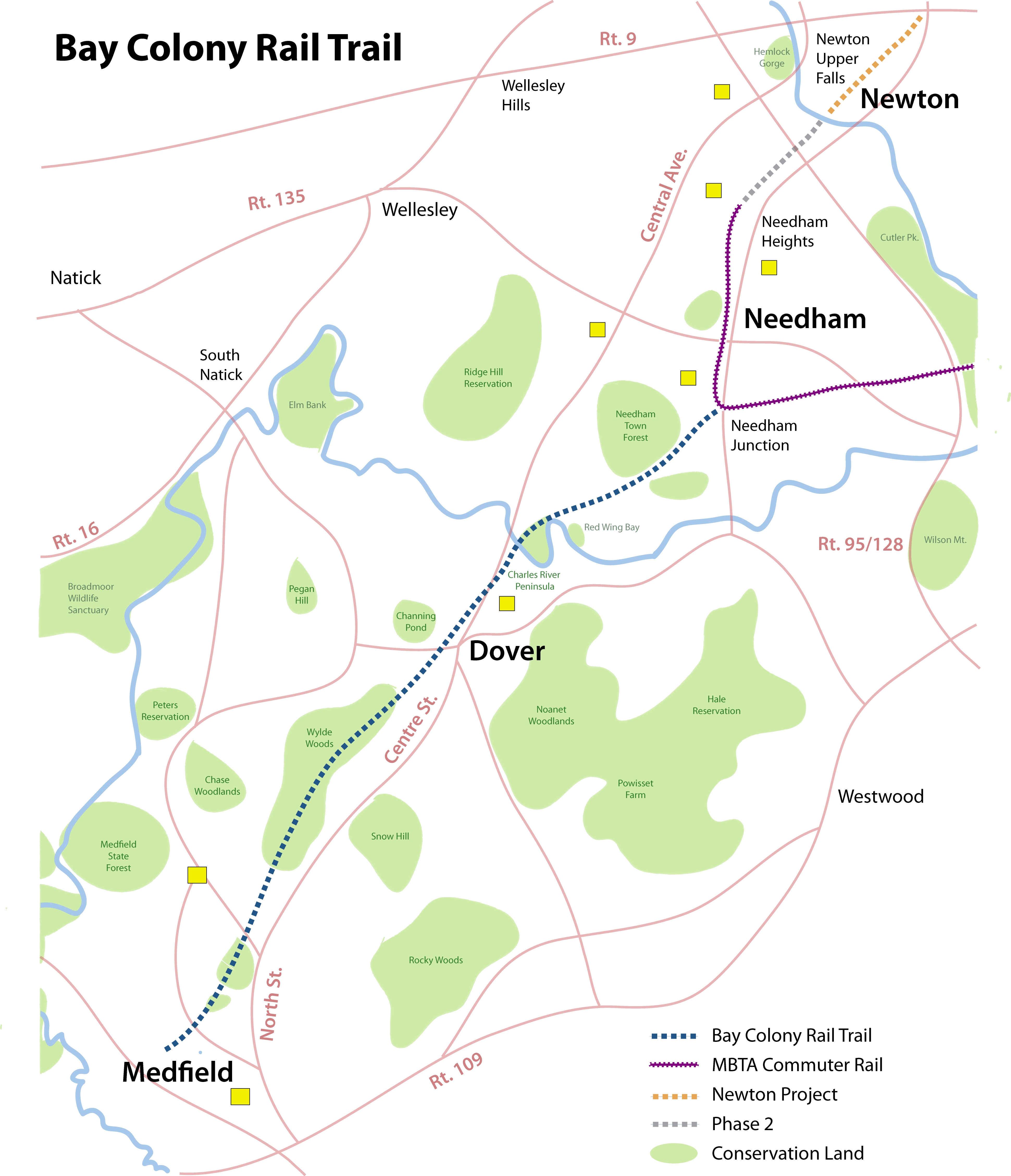
The proposed trial will extend for 7 miles through the towns of Needham, Dover and Medfield. (See map)
Needham: 2 miles from High Rock St. near Needham Junction to the Charles River. It passes the Town Forest and runs to the beautiful Charles River Peninsula, a Trustees of Reservations site.
Dover: 3.5 miles from the Charles River to Hunt Drive. Crossing the scenic trestle bridge, the corridor passes under Centre St. through the center of Dover, and then goes through two miles of pristine conservation land.
Medfield: 1.5 miles from the Dover line from Harding towards and beyond Ice House Road.
What are the expected benefits?
Increased health and wellness resource: a trail gives residents of all ages and physical abilities the chance to exercise and enjoy the outdoors without worrying about noise and dangers of traffic.
Environmentally friendly transportation: a trail provides a viable, safe and green transportation route.
Enhanced open space protection: trails preserve and maintain natural settings.
Stronger civic pride and community identity: trails help to define “livable” towns and connect them to each other; help unite people with varying physical abilities; and aid in preservation of local history.
What is the current use of the rail line?
The MBTA owns the corridor and has agreed to lease it at no cost. The corridor is formally abandoned, and falling into disrepair.
The lease extends for 99 years. The T retains the right to break the lease if demand for rail increases.
The Boston Region Metropolitan Planning Organization (MPO) completed a study in March 1998 to determine the feasibility of extending commuter rail service westward from Needham to Millis, along the Bay Colony Railroad corridor. The study concluded that a commuter rail extension would not attract sufficient ridership to make it profitable, so any plans for public rail use on that corridor have been dropped.
In 2008, Bay Colony Railroad ceased operations on the Medfield – Newton stretch, and indicated a willingness to formally abandon its lease, reverting control back to the MBTA.
Who is managing the project?
The Rail Trail project is planned as a private-public project, where the three towns – Dover, Medfield, and Needham – share the planning, funding and administration of the initiative with private, non-profit organizations.
Each town will be responsible for all matters related to approval of the trail; policies and rules governing use of the trail; trail access, parking and issues related to the intersection of the trail and public roads; securing publicly available funding as appropriate.
In Needham, the Bay Colony Rail Trail Association (BCRTA) is working closely with the town to coordinate the project effort, propose standards for use, amenities and signage, and raise funds from private and public sources. Once the trail is developed, BCRTA will continue its work with Needham town officials and other organizations to coordinate volunteer efforts for maintaining and improving that trail as public resource, and developing and maintaining an annual budget and work plan.
Who is the BCRTA and what is their role?
The Bay Colony Rail Trail Association is a registered 501 (c) (3) non-profit with the sole mission to define, design, create and maintain the rail trail. The association is supporting individuals, committees and town governments in all three towns, facilitating communications with the MBTA and as a resource on trail development issues.
More information on the BCRTA is available at www.baycolonyrailtrail.org
How is the proposed rail trail to be used?
The proposed trial is intended to be used for hiking, walking, running, biking, cross-country skiing, and roller skating.
Does the BCRT include the abandoned rail bed from Needham Heights to Newton?
No, the Bay Colony Rail Trail Association is currently focused on the rail trail that starts at Needham Junction, runs through Dover, and ends in Medfield. The association efforts do not include other rail-to-trail conversion projects at this time.
When is the project to begin, and when will the trail be open?
Developing the rail trail is a multi-year project. The goal is to have it open sometime in 2014.
Since 2012, the association has conducted meetings with appropriate Needham town departments and began the process of meeting with property owners adjacent to the trail and all other concerned parties. .
In mid-2013, a conceptual planning and design study was completed for a trail through Needham.
In November 2013, the Needham Town Meeting approved the lease negotiated with the MBTA.
In 2014, the goal for the Needham portion of the trail is to clear the trail, remove rails and ties, put down a stone dust trail surface, and implement the maintenance program. At that time, the rail trail will be accessible to the public.
Note that each of the three towns will move forward at a different pace and will involve different organizations, depending on approval by town officials and the need to address local concerns.
What hours will the trail be open?
Each town will determine their particular policy. The current thinking is that the trail will be open from dawn to dusk. This is the policy with most rail trails.
How will the trail be maintained?
Once the trail is built, the focus of the BCRTA in Needham will be on defining ongoing maintenance and funding, and coordinating volunteer efforts to keep it clean, beautiful and usable. An escrow account is to be established to fund trail maintenance.
How will we control access to the trail?
Each of the three towns will establish policies and procedures to control access to the rail trail.
Many rail trails have had success putting moveable barriers at entrances in order to prevent unauthorized motor vehicles from entering. They allow pedestrian, bicycle and equine access. The barriers are moveable to allow emergency and maintenance vehicles entrance.
Trail use rules will be posted at every entrance.
Where will people park cars to get onto the trail?
In the initial phase, people will ride or walk to the trail. In future phases, accommodations for parking are under consideration for both ends of the trail.
Who is liable for accidents on the trail?
A study conducted by the Medfield Study Committee concluded that Recreational Use Statutes and government immunity from tort claims will protect the town from potential liability claims.
According to the experience of other rail trails as reported by the Rails to Trails Conservancy, “adjacent landowners are not at risk as long as they abstain from ‘willful and wanton misconduct’ against trespassers such as recklessly or intentionally creating a hazard. Trail managers minimize liability exposure provided they design and manage the trail in a responsible manner and do not charge for trail access.”
What are the security risks?
People using the Bay Colony Rail Trail, adjacent property owners, and the communities of Needham, Dover, and Medfield have legitimate concerns about the incidence of crime on the rail trail.
Extensive research indicates that crime on rail trails is rare. Researchers have thoroughly examined the experience of nearly 400 rail trails in urban, suburban and rural environments throughout the U.S. over more than 30 years. According to this research, there is no evidence that the development of rail trails leads to an increase in crime. In fact, it has been documented that criminal activity on rail trails is significantly lower than the overall rate of crime.
In addition to the quantitative data, a number of the research reports present anecdotal information from law enforcement officers on the incidence of crime on the rail-trails. These reports indicate that because rail trails attract activity, they can act to deter crime in areas that were previously isolated.
(See Rail-Trails and Safe Communities: The Experience on 372 Trails, prepared by Tammy Tracy & Hugh Morris, Rails-to-Trails Conservancy, January 1998, http://safety.fhwa.dot.gov/ped_bike/docs/rt_safecomm.pdf)
What is the impact on property values?
Adjacent landowners and others living near the rail trail are rightly concerned about the impact on property values. The experience of other rail trails indicates the proximity to a rail trail has no impact or actually increases the value and marketability of adjacent property.
According an analysis conducted by the University of Delaware:
“The majority of studies indicate that the presence of a bike path/trail either increases property values and ease of sale slightly or has no effect. Studies have shown that neighbors of many bike paths/trails feel that the quality of life of their neighborhood has been improved, that the trails were a good use of open space, and in the case of abandoned railways were an improvement from before the trails went in.”
Source: “Project Report for Property Value/Desirability Effects of Bike Paths Adjacent to Residential Areas,” prepared for Delaware Center For Transportation and The State of Delaware Department of Transportation, November 2006
A study published in 2006 on home prices near two trails in Massachusetts, the Minuteman Bikeway and the Nashua River Trail, found that homes near these rail trails sold at 99.3% of the list price as compared to 98.1% of the list price for other homes sold in these towns. The study also found that’s homes near the rail trails sold in an average of 29.3 days as compared to 50.4 days for other homes.
Source: “Home Sales near Two Massachusetts Rail Trails,” prepared by Craig Della Penna, Realtor®, The Murphys Realtors, Inc., Northampton, MA, January 25, 2006
What is the cost to the town?
The goal of the Bay Colony Rail Trail Association in Needham is to plan, design, create and maintain the trail at little or no cost to the towns. The BCRTA will achieve this by soliciting private grants, securing Community Preservation Act funds, seeking an allocation of state funds for transportation projects, and raising funds privately to support the full range of activities.
Needham may choose to cover some maintenance tasks on the trail, and there will be some cost impact to the highway departments where the trail encounters road crossings, but in general the cost will be negligible.
What is the environmental impact?
The BCRTA, along with the Medfield Study Committee and the Dover Rail Trail Committee, have developed recommendations by researching best practices for managing environmental risks, by searching for evidence of high-risk activities and spills in the past, and by conducting a visual inspection of the railroad corridor.
Environmental contaminants can be found on every railroad corridor and commonly include the following substances:
- Arsenic, mercury and asbestos from wood preservation, fuel combustion, and leaking gauges
- Creosote from railroad ties
- Herbicides
- Spilled or leaked liquids such as oil, gasoline, cleaning solvents, etc.
Depending on the severity of contamination, we have the option to follow one or more effective remediation techniques:
- Cut and Fill: Contaminated soil is removed and replaced by clean soil to fill the corridor.
- Exclusions: In cases where contamination is, or is perceived to be, higher, a trail developer may choose to exclude a portion of the corridor from purchase and use an alternate route to avoid human contact with the contaminated site.
- Signage and Fencing: Signage and fencing are used to keep trail users on the trail and protect them from specific contaminated sites.
- Phytoremediation: The process of cleaning contaminated soil and water with plants, phytoremediation is best used for contamination in the top layers of soil, where plants’ roots reach.
- Capping the Surface: Hard surfaces, such as asphalt and concrete, may be used to cover and isolate contaminated soil along the corridor.
Sorry, the comment form is closed at this time.